
- Sediment spiral in Veronica’s wake
- An autumn storm to ease the MHW?
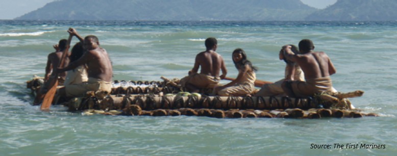
- Ancient sea journey tested with surface drifters
SST

There has been further warming in the Tasman Sea, particularly the eastern Tasman near New Zealand. Positive anomalies are reaching 2 to 3 deg C. Closer to home it is also warm along southern QLD and northern NSW coasts as the East Australian Current keeps pumping 27 deg C water as far as 34 S.
In the North West Shelf, Severe Tropical Cyclone Veronica extracted a lot of heat from the ocean to fuel its intensification. Combining this effect with strong mixing and Ekman pumping, the SST in the region has cooled dramatically. Last week that whole region was showing a 1 deg C positive anomaly and now it is largely 1 deg C negative anomaly.

storm to shake up the mhw
A strong cold front with an embedded low pressure system will bring much cooler air temperatures and a large sea state to the Tasman Sea over the weekend. Wind speeds will reach gale to storm force over a wide area. Near the centre of the low we could see significant wave heights up to 9 to 10 m on Sunday.

Behind the system the air temperatures over the ocean will be very cold, dropping by 4 to 6 deg C or more. There is even potential for snow in elevated areas of TAS and VIC.

The big injection of momentum flux and the increased latent heat loss may work to ease the marine heat wave.
Two OceanMAPS cross-sections tell the story. If we look at a transect from Eden to the northwest tip of the South Island for now(28th Mar), there is a lot of heat in the top 50 m of the ocean.
The same cross-section for the 7 day forecast (4th Apr) shows a clear cooling in the surface layers. Particularly in the western part of the transect. In the background image the area of 95th percentile exceedence also decreases.
Perhaps this storm is a most welcome thing … it may cool down our heatwave. Perhaps we could do with a few more storms like it.

Ocean impacts of TC Veronica
Currents
Ex-TC Veronica continues to leave her mark in the ocean. Residual ocean currents of at least 1 knot are circling around the area where the TC intensified on the 21st and 22nd of March. The northward current marks where a weak cold-core eddy has formed, at around 17 S 116 E.


Sediment
In the same area, visible satellite images show a large area of light blue colour that indicates sediment. During the cyclone, the momentum of the strong winds must have reached the sea bed to enable re-suspension. It is still too soon for flood waters to have reach the outer shelf.
What is interesting is the swirl in the sediment. It seems to be showing the particles being swept into the residual currents.

Most of the sediment is curling anti-clockwise, but a small arm of it is heading northward into the opposite spin around the cold-core eddy.
Sediment is a good tracer. Can we use images like this to verify our ocean models?
First Mariners deploy gliders in Timor Sea
What did it take for humans in the Pleistocene to colonise far flung islands? Answer: favourable winds and currents (and the ability to build a suitable boat).

A group called The First Mariners is attempting to re-enact a range of journeys that may have enabled the colonisation of islands 70,000 years ago. The aim of the group is to “determine the minimum technological requirements to cross those sea barriers hominins have successfully crossed during the Ice Age”.
One of the possible colonizing routes is between Timor and Darwin. The full re-enactment will take place in February 2020. At the moment the group is researching various means of propulsion.
To test the ocean current component, a team of non-professional archaeologists/scientists deploy three surface current drifters: two of bamboo and one of plastic. A GPS unit on each of them transmitted position data. One drifter survived for 38 days.

This drifter firstly went southeastward across the Timor Trench, and then moved to the northeast before coming back into the shoreline. At this time the strength of the Timor Current rapidly increased and the drifter got swept to the southwest before the unit stopped transmitting.
It certainly didn’t get to Darwin.

The First Mariners have contacted the Bureau and sent through a comparison of the drifter’s track and the OceanMAPS forecast. Some significant discrepancies were observed which may have been related to tides or the relatively coarse resolution of the model. Further investigation is planned.
In the meantime, we can speculate that Ice Age peoples would have found it difficult to reach Darwin by currents alone.
The First Mariners are now investigating the use of sails.
