
- Autumnal deepening of the mixed layer
- A CTW starts very far north
- Cartoon cat debris mystery is solved
SST update

There has been a cooling of anomalies in the southern latitudes – from southern WA through to the southwestern Tasman, as cold post-frontal air has dominated over the region in the last week or so.
On Tuesday this week behind a vigorous front there was especially strong latent heat loss along the NSW coast.

Deepening mixed layer
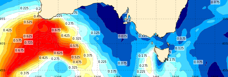
The season has changed in the profile of the upper layers of the ocean. Around much of Australia’s seas the mixed layer has deepened to over 50 m.
Contrast the two images below. The first image is from this week. In the south, a handful of cold fronts have swept through. In the northeast, cooling air temperatures and persistent SE’ly trade winds have also encouraged mixing.

The second image is from in late spring/early summer in November 2018. At this time there was strong atmospheric ridging across the Great Australian Bight, creating good insolation and heating of the upper layers. The tropical areas were also experiencing shallow mixed layers of 10 m or less before the monsoon cloud moved in.

Even given only two snapshots in time, the MLD seasonality is stark.
An interesting thing to note is that the purple region with MLDs greater than 500 m is roughly constant in both months. This indicates a thermal boundary on the northern edge of the Southern Ocean storm track.
A CTW starts in the tropics
Two tropical systems in the northwest of WA have kick-started a coastally trapped wave this week.

Sea level maps show a positive anomaly moving around the coast in an anti-clockwise direction over the next few days. The anomaly is modelled to go around the North West Cape on Saturday and then travel southward along the WA coast, before turning in the Great Australian Bight on Wednesday. When the CTW reaches the GAB, it gets an extra boost with some local forcing due to a low pressure system that is forecast to pass to the south.

Hang on? Is that going around the NW Cape? CTWs don’t usually survive past the Cape. The shelf is too narrow and the propagation speed slows down (Pattiaratchi et al 2016). We tend to think of CTWs as developing further down the coast near Perth, and then freely propagating between Hillarys in the southwest and Cape Ferguson in the northeast (Woodham et al 2013).
In the Hoevmoller above, we can draw a line with our eyes that shows this wave travelling from Broome all the way to Portland and beyond.
But perhaps it is actually two events. The first CTW that manages to get around the NW Cape but then slows down dramatically (moving more vertically in the plot), and then a second CTW that starts on the 14-15th of Apr at Cape Leeuwin and then moves with more regular speed towards Portland.
So … an amazing CTW that travels around the whole country? Or a lucky coincidence? I’ll let you decide.
Awash with Garfield phones
A mystery has been plaguing the Iroise Marine Park area of France along the rugged coast of Brittany. Why have Garfield phones been washing ashore for decades? Where did they come from?
Over the years, locals have picked up hundreds of pieces of the phones, including paws, headset cables and even Garfield heads, forever fixed in his familiar smirk. But nobody knew exactly where they came from. – NY Times

Anti-litter activists conducted a media campaign that eventually caught the eye of a local farmer who remembered a large storm in the 1980s. During the storm, he and his brother saw a large number of phones on the beach. He also recalled reports of a shipping container in a remote sea cave at the very tip of Finistère.
Volunteers gained access to the cave at low tide and found a metal structure of the shipping container and a large number of intact Garfield phones.
The notsalgia-inducing cuteness of the popular phones from the 1980s has caused this plastics story to be broadcast around the world – France TV, BBC, NY Times, ABC. But the crux of the story is worrying.
The leader of the volunteer group, Claire Simonin-Le Meur, described a feeling of “desolation and sadness” that so many of the phones were in virtually new condition. The material has not decomposed after 30 years of winds, waves and tidal forces. Plastic pollution endures beyond human lifetimes.
Without knowing the exact location of the cave (somewhere near the tip of Finistère), nor the beach were the parts are generally found (neither are given), it is hard to conduct drift analysis of the phone parts. Especially given the complex bathymetry of the region.
A quick look at OceanMAPS indicates that the geostrophic ocean currents are weak.

But those who are familiar with the area would know that it is tidally dominated, with some of the largest tides in the world. Maximum tidal currents varying between 0.75 and 4 m/s (Thibault and Senchev 2016), depending on where you are. The region is also one of Europe’s wave energy hotspots due to frequent North Atlantic storms (Michard et al 2015).
With so much water moving around due to strong tides and waves, there are expected to be many Garfield phones still out there… waiting to be washed ashore and take your call.
Please note that the Ocean Outlook blog will be taking a short break. The next blog will be issued on the 2nd or 3rd of May.
