
SST
Similar pattern to last week with good cooling in the north, but pockets of warm water continuing in the south.

Very warm in the south of WA near Albany, over 2 degrees C above average. Then this anomaly continues along the Leeuwin Current pathway along the South Australian coast, and then down the western coast of Tasmania.
SLA and currents
The coastally trapped wave that I point out last week is now in South Australia. It was kick started by the cold front off WA a few days ago and now is propagating around the south of the country.
If we look at SLA (and ignore the active eddy regions) we can watch the signature of higher sea level go along Victoria tomorrow, then slip around the corner and travel northwards up the NSW and then the southern QLD coast tomorrow night.

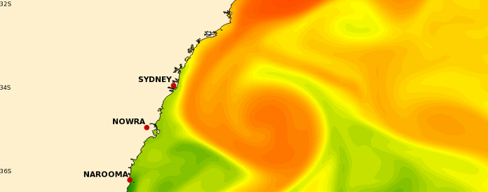
Off the coast of NSW we have a near circular large warm eddy off the coast of Sydney. The surface temperature is now around 22.5 degrees, much cooler than a few months ago. However this is a major system. It is well-mixed and at a constant 22 degrees C down to about 250 m depth. The feature has warmer water than the surroundings down to about 1000 m depth. This anomaly is generating strong geostrophic currents of 3 knots at the surface. These southward currents are in the opposite direction to the waves in the next few days and will generate short sharp steep sea state.

