
Storm surge and Antarctic swell
This weekend hailed a tropical cyclone dance on the mid-north WA coast, while massive waves impacted SA, VIC and TAS coasts. Both events honed in on regions where marine heatwaves have stretched over months.
Tropical Cyclone Seroja (and Odette)

A tropical low developed in early April in the Savu Sea. After wreaking havoc in Indonesia and Timor-Leste (more than 80 deaths and thousands displaced), it tracked southwest, strengthening into TC Seroja on 4 April.

With a second nearby tropical low also intensifying into a cyclone (TC Odette), fingers around the world typed Fujiwhara effect into Google, and forecasters had their work cut out trying to predict how the two would dance around each other.
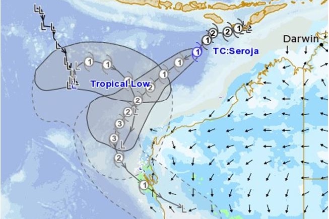
After interacting with Odette and then strengthening, the Category 3 Seroja crossed the coast at speed just south of Kalbarri after destroying Carnarvon’s One Mile Jetty . The Aqualink buoy offshore of Shark Bay recorded the waves built up by the storm.

The National Storm Surge model indicated a surge component of around 2.5m at the furthest inlet of Shark Bay.

00:00 UTC 
06:00 UTC 
10:00 UTC
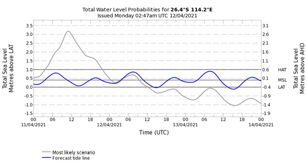
Geraldton’s water level rose well above the highest astronomical tide of 1.134m.

The reported damage so far (especially in Kalbarri) has been significant, in part because a cyclone across land this far south is relatively unusual, so buildings are not built to withstand one. While the course of Seroja was ultimately determined by the interaction with Odette, the Ningaloo Niño (a months-long marine heatwave in the western waters) played a part in strengthening both systems, particularly Seroja, as it tracked south over sea surface temperatures 2-3 degrees above average.
The beginning of the end of the heatwave?
Having given some heat to the cyclones, do we now see signs of relief from the heat? Yes! At least, on the top. While still warm, the surface anomalies are much reduced, even as far south as Perth.


Notably in those charts above, we also have a reduction in the sea surface temperature south of Tasmania, where waters had similarly been languishing in a long-lasting heatwave. This reduction in heat is thanks to a cold Antarctic air mass that swept in from the southwest during the weekend, generating a large and intense swell with a long fetch.

The Bureau’s Cape Sorell Buoy recorded waves of over 16 metres, with a period of 22 seconds.

While the VIC and SA coasts didn’t see waves quite as big, the highly energetic swell left its mark. 11 metres recorded at Point Nepean, VIC, and 12 metres recorded off Kangaroo Island in SA.


Another cold front is now pushing through the bight, which will further accelerate the seasonal deepening of the mixed layer and possibly bring further cooling to the Tassie waters. Watch this space!


