
SST
Cool anomalies persist in the northwest, southwest and south of the region. This week, cool temperatures are also seen along parts of inshore WA due to persistent southerlies causing localised upwelling. This should ease back in the next few days.
In the far northwest, the Timor Sea, there are some signs that the anomaly has returned to neutral as temperatures recover to average values for this time of year. This is good news for the development of northwest cloud bands that can bring rain to Australia’s interior.

Warm water from the EAC is pushing south along the NSW coast, and this has reduced the cool anomaly. Temperatures are now only 0.5 to 1 degree below the monthly average. However, southern NSW near Ulladulla remains cool with SSTs of only 15 to 16 deg C.

SLA and currents
Eddy-olysis
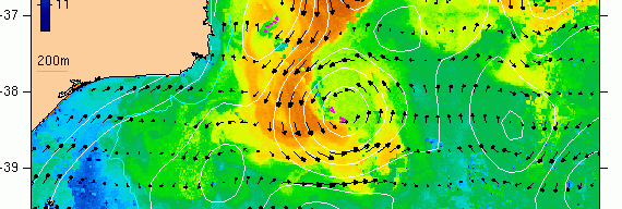
There is an old warm eddy centred at 38.3 S 152.2 E that has been hanging around the eastern tip of Victoria since the second half of 2017.
For the past several months most of the heat for the warm core has been sitting at depth. But now, this heat signature is increasingly hard to see.

IMOS OceanCurrent has the eddy as a well-defined feature from altimetry information. The currents shown here are purely geostrophic: calculated using sea level anomalies from a 10 day period (centred -5 days to +5 days). The pink arrows of a surface drifter from the 19th of September curl in tightly around the eddy and appear to verify it.

However, OceanMAPS is not so sure….
Two of the last three runs of OceanMAPS have wiped out the feature.
In the below graphic from BNOC, the centre image is the latest run, which has a weak positive anomaly in the eddy’s location. The other two runs have either no eddy or one located too far north. Note also the strong positive anomaly to the north in the central image – where did that come from?

Altimeter and Argo coverage in this region has been sporadic in the last few days, and perhaps has failed to constrain the solution. Although the coverage may be no patchier than usual.


As the warm core of this old eddy weakens, it may be increasingly hard for ocean models to resolve it.
Upwelling in the Bight
After all the coastally-trapped waves of the winter season causing multiple positive sea level anomalies events along the Bight, here comes a large scale negative event.
The WA heat trough will extend southward over Albany on the weekend. Compression between that and a high pressure ridge to the south will generate a fresh east to northeasterly wind on the 22nd and 23rd of September. This will cause large scale upwelling along the South Australian coast.
OceanMAPS is forecasting negative SLAs of up to 0.4 m.

The sea level viewer shows that in many places the sea level could go below Lowest Astronomical Tide (LAT). This will have consequences for shipping under keel clearances and some fisheries.

BOM’s climate team has done some statistical analysis on low sea level events for Port Adelaide and have found that:
- On average there are 26 hours of exposure to sea levels below LAT per year
- On average there are 1.2 hours of exposure to sea levels below -0.2m per year
- There are statistically significant decreases in both exposures. Below-LAT exposures are decreasing at a rate of 8.4 events per decade, and below-‘-0.2’ exposures are decreasing at a rate of 0.65 per decade.
These are rare events and becoming rarer. However, given the uncertainties in the formation of the heat trough that will cause this upwelling, it would be safe to throw some salt into this forecast and check in again in a few days’ time to see what happens.
Sound Speed
Shelf edge ‘cliff’ in sonic layer depth
Along the Bonney Coast a sharp gradient in sonic layer depth has developed recently across the continental shelf edge. It is as shallow as 22 m inside the shelf, to 610 m off the shelf edge.

A cross-section of temperature tells the story.


Inshore on the continental shelf there is a warm shallow layer of 14 to 14.5 deg C. The bathymetry drops off very quickly from 100 m to more than 1000m.
A very deep mixed layer is evident just outside the shelf. The thermocline then slopes upwards away from the coast.
Far out to sea the sea temperature is well mixed at 9 to 10 deg C at the surface.

Case of interest with respect to ensemble forecasts.
Would seem that extreme disagreedment in the lagged ensemble reflects uncertainty – but not a lot to go from.
The time scale is relatively long too.
With current forecast the dip period could be ~5days.
Post-event: actual measurements were less extreme.
The lowest we saw at Inner Harbour was -0.15 m at 1330Z on 24 Sep.
Thevenard near Ceduna recorded -0.14 m at 2130Z on 23 Sep.