
- Drought worsened by cool water in the northwest
- SSTs bouncing towards spring
- Max Indonesian Throughflow
- Mixed layer dynamics off Sydney
SST
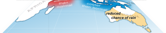
Around the country we can see neutral to cool anomalies in sea surface temperature, particularly in the southwest and northwest. The western anomalies are persisting since their development in August. The cooler water has been blamed as a significant factor for the drought in central NSW.

Cool anomalies in the northwest discourage convection and reduce heat and moisture transfer to the atmosphere. VIC and NSW forecasters often look for a ‘northwest cloudband‘ of warm, moist tropical air that can sit over northern WA. When a cold front crosses the southwest of the country, it can link up with a northwest cloudband and form an extended trough that draws tropical moisture southward. In this way rainfall can occur further inland than a pure cold front on its own.
The low rainfall has also been exacerbated by a high pressure ridge across the centre of the country has been persistent through winter and has not allowed the cold fronts to penetrate northward, meaning most of the rainfall in August fell in southern states, particularly south-west WA and western Tasmania.
BOM’s Climate team is very concerned about the cooler waters in the northwest, as the anomaly may herald a start of a positive Indian Ocean dipole event. Indeed many climate models suggest a positive IOD developing in October.

A positive IOD event is marked by easterly wind anomalies and regional upwelling in the northwest of Australia, bringing cool water to the surface and reducing atmospheric convection. This can change the path of approaching weather systems and contribute to less rainfall and higher than normal temperatures over much of Australia. In 1982, southeastern Australia had its driest year on record when a positive Indian Ocean Dipole coincided with an El Nino. For now, we remain on watch for both the IOD and El Nino.

Elsewhere around the country, sea surface temperatures are showing signs of spring: bouncing up after hitting annual minimum values in the last couple of weeks. This is most evident in Port Phillip Bay where the shallow basin has warmed rapidly in the last few days from a minimum of 9.9 degrees to 11.1 degrees today. The open ocean outside the heads is slower to respond to surface heating and remains at 13 degrees C which is the climatological minimum.

Sea level anomaly and currents
Indonesian Throughflow
The Indonesian Throughflow is at maximum strength as a sharp pressure gradient forms due to a temperature and sea level discontinuity between each side of the Indonesian archipelago.

The cooler water on the southern side is linked to the possible IOD event, but is also driven by upwelling along the southern Java coast. Peak upwelling season in Java is in August when the south-easterly trade winds are most consistent. Upwelling also causes a negative sea level anomaly.
A cross section of temperature is shown below, where the Lombok Strait is marked by land (grey). The sharp discontinuity is apparent: warmer waters and a deeper mixed layer on the northern (left) side of the image.

The resulting pressure gradient between north and south is what drives the Indonesian Throughflow. Total peak transport is typically in August at 12 Sv (Meyers et al 1995).
This transport is causing strong currents. OceanMAPS model output suggests surface current speeds up to 2 m/s (4 knots) in the Lombok Strait, while Ombai Strait has 1.3 m/s and the Timor Strait has 0.9 m/s. At this strength the currents would be impossible to swim or paddle against.


Warm eddy off Sydney
The ocean temperatures remain very cool in Sydney coastal waters, hovering at about 15 degrees C. This is 1.5 to 2 degrees below the seasonal average. Offshore, it is a very different story due a large warm-core eddy.

A cross-section of temperature from cold inshore waters through the warm eddy shows big deviations in the mixed layer depth. The inshore waters of 15 deg C (light blue) are of Tasman Sea origin. Far out to sea (far right of the image) these temperatures exist in a well-mixed layer from the surface down to a depth of 250 m.
In contrast, the warm eddy has temperatures of 18 to 19 deg C to a similar depth of 250 m. This pushes the 15 deg C isotherm down to 350 m underneath the eddy.

worth a highlight that access-s is now in operations and used for the climate charts.