
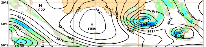
Ahead of a major cold air outbreak and cut-off low in Australia’s southeast, and with fine weather and mild ocean conditions dominating the rest of the country, we will focus today’s post on VIC and NSW.
SST
The warm water at the end of the East Australian Current has sea surface temperture of 24 degrees C which is up to 2.5 degrees above average. The hot spot is centred between 35 and 36 S, about 120 nm offshore. The waters inshore are at 19 degrees C. As the cold air outbreak moves over these warm inshore NSW waters on Saturday the 12th we will see plenty of convective activity, but we could look for extra convective energy as the air reaches the SST front offshore. If the atmospheric conditions are right a jump in 5 degrees of SST is significant enough to cause local convergence lines or convective cells.

Sea level anomaly
SLA forecasts in the EAC region are showing significance variance run to run. The image below shows three scenarios from the last three OceanMAPS runs for the same timestamp: the warm extension may either be cut off into a closed warm eddy, be pushed further south into an extended arm, or be split into two by a strong cold eddy to the east. In all scenarios this lobe is cut off from the main Tasman Front which retreats to the north.

Some of the ocean uncertainty is linked to atmospheric uncertainty in this cut-off low event. This is easier to see in the SST signature (see images below). Looking at the difference between today’s and Sunday’s forecast, we can see the effect of the expected strong southerly winds along the VIC and NSW coasts. The winds will push the cooler waters northward. However on the return side of the low pressure system the northerly winds will push the warmer waters southward. The vigorous system could also mix a lot of the heat into depth and weaken the structure of the warm eddy.


Aggregate Sea level
The cut off low will cause storm surge along the coast, with water levels near HAT expected at Lakes Entrance on Friday. The surge component is expected to be around 30 to 40 cm. We are in neap tides at the moment, but this surge brings the sea level up to HAT on Friday afternoon (06z). Luckily this does not coincide with the maximum waves pushing onshore which are expected later that night. However there is another sea level peak early Saturday morning that is only 10 cm lower than HAT and will coincide with a lot of wave energy pushing onshore as well as the rain outflow from the lakes. A flood watch is in place and a storm surge warning has been issued to stakeholders.

Later in the forecast period the sea level surge pushes further up the coast into northern NSW and southern QLD into Monday to Tuesday (see red dots in the image).
