
SST
Along with the warmer air temperatures over the past week, the sea surface temperatures have also remained warm overall. Anomalies are picking up – mainly because the climatology is sliding into autumn temperatures but reality is lagging behind. Almost the whole north and west of the country is very warm, along with the Great Australian Bight and most of the Tasman Sea.

A ‘real’ anomaly, if you like, is along the NWS where temperatures continue near 31 to 32 degrees C due to persistent light winds in the area.

The GAB is another warm spot. The Leeuwin Current is pushing southward (as it does in autumn and winter) but the seas it is pushing are warmer than usual which is spiking an anomaly.
Warmer air and sea temperatures are expected to continue into May, as explained in an article in The Conversation today. The only areas that are normal or cool at the moment are the QLD coast where TC Iris sucked up a lot of heat, some of middle WA, and the Victorian coast.
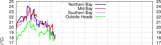
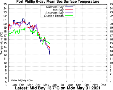
For those of us living in Melbourne, Port Philip Bay has cooled down significantly in the last month. From a peak at 24 degrees in February where it was a warm bath compared to the ocean outside the heads, it is now down to 18 degrees which is the same temperature as the ocean. See the plots from BayWx.com.au below. Hence our relatively cool temperatures in the last couple of days when the wind has been from the south (compared to the heat event inland).
Sea Level Anomalies and Ocean Currents
The giant loop of warm water off NSW continues. Some of the cooler water to the east (the cold eddy seen here) may push northwestward and squeeze the top of the loop. Warm water may be siphoned off at the south end to form a pool that may become yet another warm eddy as far south as Victoria.
The take-home message is that although temperatures are cooling inshore (currently at 21 degrees along the NSW coast), there is plenty of heat sitting offshore at 24 to 26 degrees C for at least the next week, if not longer, and this will enhance any convection in the area.
The forecast of the precise shape is changeable, as seen in 7 day forecast of the three latest runs below.

Aggregate sea level
Sea levels are expected to exceed HAT along the SA, VIC and TAS coasts on Saturday as a strong cold front brings coastal surge along with an inverse barometer effect. Large waves with long period swell are also expected, up to 9 m significant wave height along the Bonney Coast. The sea level product does not include wave setup. The combined effect of the high sea level plus the waves may put coastal areas at risk.

