
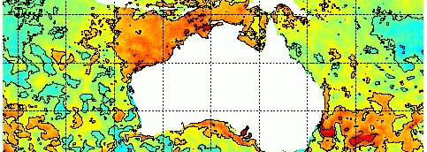
SST
Sea surface temperature continue very warm around much of the country. This is especially the case to the north and the west, also along the GAB due to the Leeuwin Current, and off the NSW coast. Cool temperatures are seen in middle WA, especially inside Shark Bay, due to recent upwelling from persistent SE winds.


Off the coast of NSW there is still a lot of heat in the ocean with SSTs of 25 degrees. This is up to 3 degrees higher than average in places. There is a chance that an east coast low develops next week and this heat source will likely enhance precipitation with such a feature.


Sea Level Anomalies and Ocean Currents
The large loop of warm water off NSW still shows as a strong positive sea level anomaly. An arm of cooler water is propagating northward to the east and looks like it will form a cold eddy that will ‘almost’ pinch off the warm water into a closed warm eddy by next week. The image below shows the 7 day forecast for Wednesday the 25th of April.

A strong front approaching WA on the weekend will build sea level against the coast – due to combination of surge and downwelling. This will cause a positive sea level anomaly on Saturday that will propagate around Cape Leeuwin and along the Great Australia Bight as a coastally trapped wave. These features typically propagate all the way along Australia’s southern coast at a phase speed of about 9 m/s, and often turn left and travel up the NSW and QLD coasts albeit at a slower pace modified by the width of the continental shelf. For more details, see the paper Woodmans et al 2013.

