
SST
It is cooling down in the west, with negative anomalies developing in southwest and northwest WA.

The northwestern anomalies off southern Indonesia are caused by upwelling from the south-easterly tradewinds. Upwelling along the Javanese coastline peaks in August to September (Sunsanto et al 2001). The cooling may also be related to a developing positive Indian Ocean Dipole event, although the index is still within the neutral bounds.
The southwestern anomalies are likely to be related to the frequent extratropical lows and associated cold fronts that have swept through WA in recent months. The fronts have brought cold air and extensive rainfall to the coast. Strong winds around these systems has caused mechanical mixing of the surface waters, deepening the mixed layer and cooling surface temperatures.
#Perth is experiencing the wettest start to August in a long time. Up to 9am this morning we’ve had 101.6mm. This is wettest first 9 days at Mt Lawley on record (back to 1993), and wettest in #Perth since 1945 (103.1mm). Chart shows cumulative total this year compared to ave. pic.twitter.com/GUDBG3oxJu
— Bureau of Meteorology, Western Australia (@BOM_WA) August 9, 2018
A vertical profile of the 5th percentile, below, shows that in the cool patches the temperature ‘exceeds’ the 5th percentile value down to 155 m below the surface. Below that the water is warmer than the percentile value.

Temperature profiles show mixed layer depths of 185 m to the southwest of WA. Meanwhile, in the active Leeuwin Current region, mixed layer depths vary between 115 m in a cold eddy (beige dot) and 205 m in a warm core eddy (green dot).

Meanwhile on the east coast, the sea surface temperatures are anomalously warm along the EAC extension, with a pocket of cooler water inshore near Sydney.

Sea level
Can coastally-trapped waves (CTWs) go backwards? A recent sea level signature in northwest WA suggested a negative anomaly propagated clockwise around the country rather that anticlockwise.
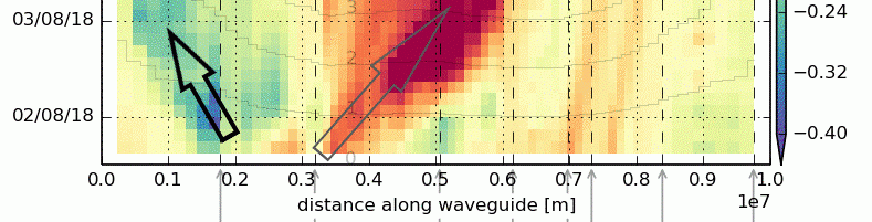
A Hovmöller plot of sea level anomaly is shown below for the first week of August. At least two CTWs can be seen moving eastward from Cape Leeuwin towards Ceduna in South Australia. These are marked by the grey arrows: a large positive anomaly on the 2nd of August and a weaker, slower-moving negative anomaly on the 5th of August. Both events can be linked to downwelling/upwelling processes triggered by the passage of strong cold fronts.

At similar times, two negative sea level anomalies occur at the Northwest Cape and appear to move in the opposite direction: towards Darwin. These are marked by the black arrows.
Are these propagating waves?
Tide residuals from gauges at various locations on the WA coast are shown below (ordered from north to south). See the negative anomalies on the 2nd and 5th of August, with the events occurring slightly earlier at southern stations.


CTWs are a hybrid type of wave, with characteristics of internal Kelvin waves (due to stratification) and topographic Rossby waves (due to vorticity gradients across a continental shelf). Pure Kelvin waves can travel in both directions. However, CTWs are rarely ‘pure’ waves. In both in-situ measurements and laboratory experiments, they are observed to travel clockwise in the northern hemisphere and anti-clockwise in the southern hemisphere (Baines et al 2004).
Typically, CTWs are found between the southwest and northeast coasts of Australia, with the greatest spectral power located in the Great Australian Bight (Woodham et al. 2013). The NW Cape is not known for CTW generation.
A look at the atmospheric situation during both events shows high pressure systems moving into WA following cold front passage. There were strong southerly winds on the front edge of the highs.


On closer analysis, it seems that the sea level anomaly was not a propagating wave but a result of propagating forcing. This is suggested in images of the wind speed and direction for just after the second event (6-8th August), shown below.
![]()
![]()
![]()
As strong high pressure moves in, the first surge of winds are southerly and then they back southeastly to easterly. Southerly winds would drive upwelling near the NW Cape. Southeasterly winds would drive upwelling near Broome. As the wind backs in direction, the coast curves too.
The propagating forcing prevents us diagnosing these events as CTWs, and therefore they are not ‘travelling backwards’. At least this time.
